‘Mysterious Tubes’ Explained – All Otsego

Advertisement. Advertise with us

GOALS: SAVE LOCAL FARMLAND, CHESAPEAKE

‘Mysterious Tubes’ Explained

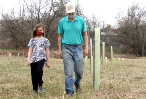
BVA’s Graham Stroh and daughter Asher, 8, examine a “riparian buffer” off Route 23 east of the Village of Morris. (Jim Kevlin/AllOTSEGO.com)

People entering Morris on Route 23 from Oneonta kept asking Bob Thomas, town historian and a Butternut Valley Alliance board member, “What are those tubes across from the cemetery?”

With his nudging, couple of weeks ago an enticingly titled Zoom presentation, “Mysterious Tubes Along Butternut Creek,” provided the answer to 27 participants, some landowners who may sign up to host mysterious tubes of their own, according to BVA Executive Director Graham Stroh.

The program’s been going on for a decade, according to Lydia Brinkley, Upper Susquehanna Coalition buffer coordinator, “riparian buffers,” that is.

If you’ve only noticed the mysterious tubes lately, it’s because there are more of them, part of the USC’s federally and state-funded efforts to clean up Otsego County’s streams, and thus contribute a bit to the restoration of the Chesapeake Bay, 250 miles south of Garrattsville.

“Riparian buffers are essentially wooded areas along creeks and rivers, for purposes of reducing erosion and stabilizing stream banks,” said Stroh, formerly an urban planner in Washington D.C. who moved back three years ago to manage the family’s property. (He was raised in New York City; his dad, Leslie, in Morris.)

The Butternut Valley, and with the collaboration of the Middlefield-based Soil & Water Conservation District, all of Otsego County’s streams, are part of a “huge, huge region,” said Stroh, where efforts are underway to clean up the tributaries to the Susquehanna River, which eventually runs into the challenged Chesapeake, where pollutants have been destroying the rich fishery for decades.

“Point source pollution” – sewage discharge, for instance – “those are relatively easy to manage,” said Stroh. Non-point sources are more difficult.

“One of the simplest solutions is to move agriculture away from the river, and plant the sides of the river with trees that had been removed from clear-cutting at the turn of the last century, or erosion,” he said.

When vegetation that holds a riverbank is lost, erosion “goes wild,” slicing away rich farmland and reducing productive fields, he continued. Thus, it makes sense for some farmers to look toward riparian buffers to keep their farms intact, and thus they reach out to the BVA or UCS.

All the buffers you see result from voluntary collaborations. “Nobody is forcing this to be done,” said Stroh.

“The benefits are huge,” he continued. “When you get that forested edge, in addition to stopping the erosion, it also creates

Inside “mysterious tubes,” plants grow.

habitat areas for wildlife, and shades rivers, which helps reduce algae
and grasses.

“It actually cools the water. Cool water supports more trout, and other fish as well.”

Even a small effort like the BVA’s is a big challenge: The Butternut Creek is 21 miles long; with tributaries, there are 120 miles of streambeds in nine towns.

Little by little, though, progress is being made. In 11 years, 60 acres have been restored though riparian buffers, some 30,000 feet (six miles) of streambank.

That afternoon, Stroh, with daughter Asher, 8, was striding through a plantation of mysterious tubes on that parcel that inspired Bob Thomas to propose the presentation.

By the Route 23 bridge, you can see the dramatic result of erosion: Where once a meadow gently sloped toward the water, today you’ll stand at the edge of a cliff as tall as one medium-sized man standing on another medium-sized man’s shoulders.

“The Butternut is a beautiful, clean creek, with an amazing assortment of native wildlife, mussels, hellbenders – eels were stocked here a few years ago.

“We still need to get landowners to see how they can help and be part of it,” Stroh said, “but all this has made us a little bit of a star in the Upper Susquehanna watershed.”

Posted

2 Comments

  1. The Otego Creek has eroded our field over the years. Is there a way that this idea would be available to us in order to stop the constant change in the flow of the Creek

  2. Contact Otsego County Soil and Water Conservation District for riparian restoration assistance! (607) 547-8337 ext 4

Leave a Reply

Your email address will not be published.

Related Articles

OCCA Expands Programs with National Grant

The project will engage members of the public in collecting data about streams, lakes and stream crossings. The data collected through this initiative will provide essential insights into local watershed conditions and establish robust groundwork for future restoration projects aimed at enhancing aquatic habitats.…